geo.wikisort.org - Río
El río Gunt (históricamente también Ghund[1]) es un río que discurre por el sur de Tayikistán. Su fuente, el lago Yashilkul, está situada en el borde del Alichur Pamir, una altiplanicie o pamir a una altitud de 3720 m. La ciudad de Khorog está localizado en la confluencia del Gunt con el río Panj (este último, formando la frontera entre Tayikistán y Afganistán y siendo conocido también como Amu Daria, o como era llamado en la antigüedad ,Oxus).
| Río Gunt | ||
|---|---|---|
 | ||
| Ubicación geográfica | ||
| Cordillera | Pamir | |
| Región | Asia central | |
| Cuenca | Amu Daria | |
| Nacimiento | lago Yashilkul | |
| Desembocadura | Río Panj | |
| Coordenadas | 37°37′51″N 73°58′41″E | |
| Ubicación administrativa | ||
| País | Tayikistán | |
| División | Provincia de Alto Badajshán | |
| Cuerpo de agua | ||
| Origen | nivo-glaciar | |
| Longitud | 296 km | |
| Ancho máximo | 10-50 m | |
| Superficie de cuenca | 13 700 km² | |
| Caudal medio | 106 m3/s, en la confluencia | |
| Altitud |
3 719 metros Nacimiento: 3720 m Desembocadura: 2062 m | |
| Ciudades costeras | Khorog | |
| Mapa de localización | ||
 Río Gunt | ||
 | ||

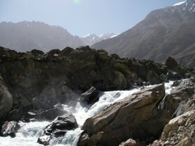
El río Gunt —y su afluente el río Shahdara, que alimenta la planta hidroeléctrica Pamir I— es muy estacional, con poca agua en invierno, pero alto en julio y agosto debido al agua de fusión de la nieve. Su ancho varía de 10 a 50 metros y tiene hasta 1.5 metros de profundidad. Debido al terreno montañoso, el curso del río es muy rápido, superando los 2 m/s en algunos tramos y épocas. Su lecho es pedregoso y las riberas son empinadas y con precipicios. A menudo la corriente ocupa el valle entero del río, pero a veces se divide en varios cursos.
Véase también
Provincia de Alto Badajshán, para el entorno.
Notas
- «The Geographical Journal». Royal Geographical Society. 1896. Consultado el 16 de diciembre de 2019. «From its western extremity issues the Ghund or Gunt river, which, after its junction with the Shakh Dara confluent of the Oxus lower down, flows for a few miles under the title Suchan Dara, and disembogues into the main stream of the Panja, a little above Kala Bar Panja, the capital of Shighnan. »
Referencias
- Esta obra contiene una traducción derivada de «Gunt River» de Wikipedia en inglés, publicada por sus editores bajo la Licencia de documentación libre de GNU y la Licencia Creative Commons Atribución-CompartirIgual 3.0 Unported.
Enlaces externos
- Puerta de Desarrollo del Tayikistán (Ríos)
- Debris Flujos (fotografías)
- Tokharistan Superior (Pamir)
- Mapa del Gunt
- Kayaking y raftings de aguas bravas
| Control de autoridades |
|
|---|
 Datos: Q1554866
 Multimedia: Gunt river / Q1554866
На других языках
[de] Gunt
Der Gunt (russisch Гунт) ist ein rechter Nebenfluss des Pandsch in der Region Berg-Badachschan in Tadschikistan. Die mittlere Geländehöhe des Einzugsgebietes beträgt 4261 m[2]. Der höchste Berg ist mit 6723 m der Pik Karl Marx.[3][en] Gunt
The Gunt (Russian: Гунт, Tajik: Ғунд Ghund or Аличур Alichur, historically in English also Ghund[1]) is a river in the south of Tajikistan, north of the Shughnon Range. It is 296 kilometres (184 mi) long and has a basin area of 13,700 square kilometres (5,300 sq mi).[2] Its source, Lake Yashilkul, is situated at the edge of the Alichur Pamir, a high plateau or pamir at an elevation of 3720m. The city of Khorog is located at the confluence of the Gunt with the Panj (one of the source rivers of the Amu Darya, forming the border between Tajikistan and Afghanistan). See Gorno-Badakhshan Autonomous Region for surrounding area.- [es] Río Gunt
[ru] Гунт
Гунт (Гурумды[1], Ири-Як[1], Аличур[1]) — река на Западном Памире в Таджикистане, правый приток Пянджа. Начинается от слияния Ирису и Кульджилги[1].Другой контент может иметь иную лицензию. Перед использованием материалов сайта WikiSort.org внимательно изучите правила лицензирования конкретных элементов наполнения сайта.
WikiSort.org - проект по пересортировке и дополнению контента Википедии