geo.wikisort.org - Mar
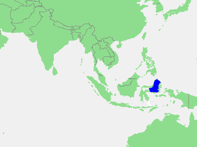
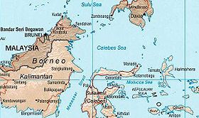
El mar de las Molucas (en indonesio, Laut Maluku) es un mar que se encuentra en el océano Pacífico occidental, y cuyas aguas pertenecen a Indonesia. La región es rica en corales y tiene muchos sitios de buceo.
| Mar de Molucas | ||
|---|---|---|
| Laut Maluku | ||
| Océano o mar de la IHO (n.º id.: 48c) | ||
| Ubicación geográfica | ||
| Continente | Oceanía | |
| Océano | Océano Pacífico | |
| Isla | Célebes, Islas Talaud, Halmahera, islas Bacan, islas Obi, Taliabu, islas Banggai y Peleng | |
| Coordenadas | 0°25′00″S 125°25′00″E | |
| Ubicación administrativa | ||
| País |
| |
| División | Célebes Central , Célebes Septentrional, Gorontalo y Molucas Septentrional | |
| Cuerpo de agua | ||
| Mares próximos | Mar de Célebes, mar de Filipinas, mar de Halmahera, mar de Ceram, mar de Banda y golfo de Tomini | |
| Profundidad | Máxima: 4 970 m | |
| Mapa de localización | ||
 | ||
 | ||
Geografía
Este mar está enclavado en la parte centroriental del archipiélago de las Indias Orientales y sus límites son los siguientes:
- al noroeste, la costa de la isla de Célebes y el mar de Célebes;
- al norte, las islas Talaud, y el mar de Filipinas;
- al este, con la costa occidental de la isla de Halmahera, las islas Bacan y las islas Obi y el propio mar de Halmahera;
- al sur, con el mar de Ceram, las islas de Taliabu, islas Banggai y Peleng y el mar de Banda;
- al oeste, con el golfo de Tomini.
Historia
El mar de las Molucas fue un área activa en el comercio de especias y estuvo controlada por 4 sultanatos.
Terremotos
El mar es una zona sísmica muy activa debido a la placa del mar de las Molucas. Las islas Talaud, al norte, son el límite generalmente aceptado de este mar, aunque la plataforma marina se extiende más al norte.
Delimitación de la IHO
La máxima autoridad internacional en materia de delimitación de mares, la Organización Hidrográfica Internacional («International Hydrographic Organization, IHO), considera el mar de Molucas como un mar. En su publicación de referencia mundial, Limits of oceans and seas (Límites de océanos y mares, 3ª edición de 1953), le asigna el número de identificación 48c, dentro del archipiélago de las Indias Orientales y lo define de la forma siguiente:
En el norte.
Por una línea desde el extremo noreste de Célebes a través de las islas Siau a la punta sur de Sangi (3°21'N, 125°37'E) y desde allí hasta el extremo sur del grupo de Talaud, a través de estas islas a su extremo nordeste (4°29'N, 126°52'E) y desde allí una línea a Tanjong Sopi, la punta norte de la isla de Morotai.
En el este.
Por la costa oeste de Morotai desde Tanjong Sopi hasta al sur a Wajaboela (2°17'N, 128°12'E), y desde allí una línea hasta el extremo norte de Halmahera y por su costa oeste hasta Tanjong Libolo, su extremo sur.
En el sur.
Una línea desde el extremo sur de Halmahera a la punta norte de la isla Bisa (Setile) y desde allí hasta el extremo norte de Obi Mayor, a través de esta isla hasta Tanjong Ake Lamo, su extremo sudoeste, y desde allí a Tanjong Dehekolano, en el extremo oriental de las islas Soela, a lo largo de sus costas del norte de Tanjong Marikasoe, el extremo occidental, y desde allí una línea hasta el punto suroeste de la isla de Banggai (1°43'S, 123°36'E).
En el oeste.
Las costas orientales de las islas de Banggai y Peleng hasta Bangkalan Norte (1º10'S, 123°18'E) y desde allí una línea a Tg. Botok (Célebes) (1°04'S, 123°19'E) alrededor de la costa a Tg. Pasir Pandjang (0°39'S, 123°25'E) y en la Tg. Tombalilatoe (123°21'E) en la costa opuesta, y desde allí hasta la costa oriental de Tg. Pisan, el extremo noreste de Célebes.Limits of oceans and seas, pág. 25.[1]
Véase también
Notas
- «On the North. By a line from the Northeast extreme of Celebes through the Siau Islands to the South point of Sangi (3°21'N, 125°37' E) thence to the Southern extreme of the Talaud Group, through these islands to their Northeastern extreme (4°29' N, 126°52' E) and thence a line to Tanjong Sopi, the Northern point of Morotai Island.
On the East. By the West coast of Morotai from Tanjong Sopi as far South as Wajaboela (2°17' N, 128°12' E), thence a line to the Northern point of Halmahera and down its West coast to Tanjong Libolo, its Southern extreme.
On the South. A line from the Southern extreme of Halmahera to the North point of Bisa (Setile) Island, thence to the Northern extreme of Obi Major, through this island to Tanjong Ake Lamo, its Southwestern point, thence to Tanjong Dehekolano, the Eastern extremity of the Soela Islands, along their Northern coasts to Tanjong Marikasoe, the Western extreme, thence a line to the Southeast point of Banggai Island (1°43' S, 123°36' E).
On the West. The East coasts of Banggai and Peleng Islands to North Bangkalan (1º10' S, 123°18' E) thence a line to Tg. Botok (Celebes) (1°04' S, 123°19' E) round the coast to Tg. Pasir Pandjang (0°39' S, 123°25' E) and across to Tg. Tombalilatoe (123°21' E) on the opposite coast, thence up the East coast to Tg. Pisan, the Northeastern extreme of Celebes.»
La traducción al español es propia. La versión original, en inglés, está disponible en linea en el sitio oficial de la «International Hydrographic Organization» en: http://www.iho.int/publicat/free/files/S23_1953.pdf (enlace roto disponible en Internet Archive; véase el historial, la primera versión y la última)..
Enlaces externos
- Esta obra contiene una traducción derivada de «Molucca Sea» de Wikipedia en francés, publicada por sus editores bajo la Licencia de documentación libre de GNU y la Licencia Creative Commons Atribución-CompartirIgual 3.0 Unported.
| Control de autoridades |
|---|
 Datos: Q185291
На других языках
[en] Molucca Sea
The Molucca Sea (Indonesian: Laut Maluku) is located in the western Pacific Ocean, around the vicinity of Indonesia, specifically bordered by the Indonesian Islands of Celebes (Sulawesi) to the west, Halmahera to the east, and the Sula Islands to the south. The Molucca Sea has a total surface area of 77,000 square miles (200,000 square km). The Molucca Sea is rich in coral and has many diving sites due to the deepness of its waters. The deepness of the water explains the reasoning behind dividing the sea into three zones, which functions to transport water from the Pacific Ocean to the shallower seas surrounding it. The deepest hollow in the Molucca Sea is the 15,780-foot (4,810-meter) Batjan (Indonesian: Bacan) basin. This region is known for its periodic experiences of earthquakes, which stems from the sea itself being a micro plate, in which the Molucca Sea is being subducted in two opposite directions: one in the direction of the Eurasian Plate to the west and the other in the direction of the Philippines Sea Plate to the east.- [es] Mar de Molucas
[ru] Молуккское море
Молуккское море (индон. Laut Maluku) — межостровное море Тихого океана, окружённое Индонезийскими островами: Сулавеси на западе, Сула, Малуку и Молуккскими на юге, Сангихе, Минданао и Талауд на севере, Северное Малукку на востоке. Площадь Молуккского моря — 274 000 км²[1]. Средняя глубина — 1752 м. Глубочайшая впадина Молуккского моря — котловина Батьян. Её максимальная глубина — 4970 м[2]. Регион Молуккского моря известен своей сейсмической активностью. Она связана с тем, что море расположено на небольшой плите, которая раздвигается в две противоположные стороны: на запад в сторону Евразийской плиты и на восток в сторону плиты Филиппинского моря.Другой контент может иметь иную лицензию. Перед использованием материалов сайта WikiSort.org внимательно изучите правила лицензирования конкретных элементов наполнения сайта.
WikiSort.org - проект по пересортировке и дополнению контента Википедии