geo.wikisort.org - River
The Var (French: [vaʁ] (![]() listen), Occitan: [ˈbaɾ]; Italian: Varo; Latin: Varus) is a river located in the southeast of France. It is 114 km (71 mi) long.[1] Its drainage basin is 2,812 km2 (1,086 sq mi).[2]
listen), Occitan: [ˈbaɾ]; Italian: Varo; Latin: Varus) is a river located in the southeast of France. It is 114 km (71 mi) long.[1] Its drainage basin is 2,812 km2 (1,086 sq mi).[2]
| Var | |
|---|---|
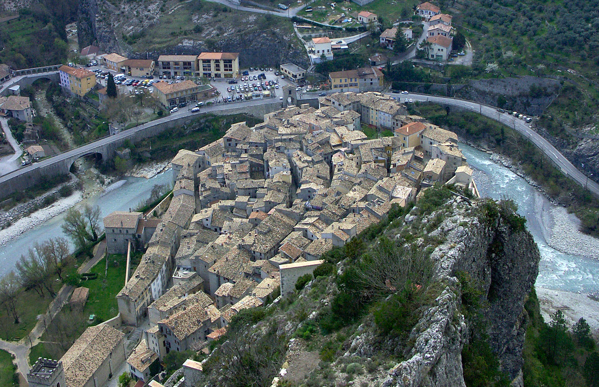 Rooftops of Entrevaux and the gorge of the Var | |
 | |
| Location | |
| Country | France |
| Physical characteristics | |
| Source | |
| • location | Maritime Alps |
| • elevation | 1,800 m (5,900 ft) |
| Mouth | |
• location | Mediterranean Sea |
• coordinates | 43°39′13″N 7°11′59″E |
| Length | 114 km (71 mi) |
| Basin size | 2,812 km2 (1,086 sq mi) |
| Discharge | |
| • average | 50 to 100 m3/s (1,800 to 3,500 cu ft/s) |
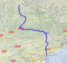
The Var flows through the Alpes-Maritimes département for most of its length, with a short (~15 km or ~9 mi) stretch in the Alpes-de-Haute-Provence département. It is a unique case in France of a river not flowing in the département named after it (see Var).
Until the beginning of the 19th century, the river had no bridges; it was the border between France and the County of Nice, then part of Kingdom of Piedmont-Sardinia.
Name
The river name is attested in Latin as Vārus and in Ancient Greek as Ouãros (Οὐᾶρος). It stems from the Indo-European root *uōr- (earlier *uer-), meaning 'water, river' (cf. Sanskrit vār, Old Norse vari).[3]
Hydrography
The Var rises near the Col de la Cayolle (2,326 m/7,631 ft) in the Maritime Alps and flows generally southeast to its outflow into the Mediterranean Sea between Nice and Saint-Laurent-du-Var. Its main tributaries are the Cians, the Tinée, the Vésubie, the Coulomp, the Estéron, the Tuébi, the Chalvagne, the Barlatte, the Bourdous and the Roudoule.[1]
The Var flows through the following départements and towns:
- Alpes-Maritimes: Guillaumes
- Alpes-de-Haute-Provence: Entrevaux
- Alpes-Maritimes: Puget-Théniers, Carros, Saint-Laurent-du-Var
References
- Sandre. "Fiche cours d'eau - Le Var (Y6--0200)".
- Bassin versant : Var (Le), Observatoire Régional Eau et Milieux Aquatiques en PACA
- Delamarre 2003, p. 301.
Bibliography
- Delamarre, Xavier (2003). Dictionnaire de la langue gauloise: Une approche linguistique du vieux-celtique continental. Errance. ISBN 9782877723695.
Authority control | |
|---|---|
| General | |
| National libraries | |
| Other |
|
This Provence-Alpes-Côte d'Azur geography article is a stub. You can help Wikipedia by expanding it. |
На других языках
[de] Var (Fluss)
Der Var ist ein Fluss im Süden Frankreichs, der in der Region Provence-Alpes-Côte d’Azur verläuft. Er entspringt beim Weiler Estenc im Gemeindegebiet von Entraunes in der Nähe des Col de la Cayolle, entwässert generell in südöstlicher Richtung durch die Seealpen und mündet nach rund 114[2] Kilometern zwischen dem Flughafen Nizza und dem Ort Saint-Laurent-du-Var in das Mittelmeer. Der Fluss verläuft fast vollständig im Département Alpes-Maritimes und durchquert auf einer Länge von etwa zehn Kilometern auch das Département Alpes-de-Haute-Provence.- [en] Var (river)
[es] Río Var
El Var es un río de Francia que desemboca en el mar Mediterráneo. Nace a unos 1800 m sobre el nivel del mar, en los Alpes, a los pies del Col de la Cayolle, en el norte del departamento de los Alpes Marítimos, y desemboca entre la ciudad de Niza y Saint-Laurent-du-Var, con un curso de 120 km y una cuenca de 2742 km². Históricamente, fue la antigua frontera natural, cultural, y étnico entra la Galia (la Francia) e Italia hasta la invasión y la anexión del condado de Niza por Francia en 1860.[it] Varo (fiume)
Il Varo (in francese e occitano Var, in latino Varus) già citato nel De bello civili di Cesare, è un fiume francese, lungo 120 km,[1] che sfocia a ovest di Nizza.[ru] Вар (река)
Вар (фр. Var, в переводе с древнего лигурийского языка — «поток») — река на юго-востоке Франции. Длина 114 км, средний расход воды — до 100 м³/с.Другой контент может иметь иную лицензию. Перед использованием материалов сайта WikiSort.org внимательно изучите правила лицензирования конкретных элементов наполнения сайта.
WikiSort.org - проект по пересортировке и дополнению контента Википедии