geo.wikisort.org - River
The Shacha (Russian: Шача) is a small tributary of the Tsna in Ryazan Oblast, Russia. It is 48 kilometres (30 mi) long, and its drainage basin covers 449 square kilometres (173 sq mi).[1] It has presented a hydrologic problem since the Globus-1 test, when it changed its course and threatened to flood the hole left by the explosion. This has the potential for spreading the nuclear pollution to the entire Volga region. Several engineers have proposed building a reinforced covering over the hole and digging a 12 km channel to shift the river away from the place of explosion. There is nearby town named Shatsk (Шацк).
| Shacha | |
|---|---|
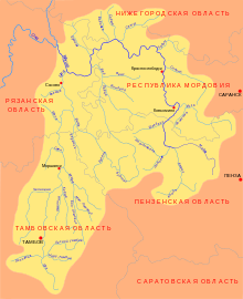 Moksha basin map | |
| Native name | Шача (Russian) |
| Location | |
| Country | Russia |
| Physical characteristics | |
| Mouth | Tsna |
• coordinates | 53.9792°N 41.8835°E |
| Length | 48 km (30 mi) |
| Basin size | 449 km2 (173 sq mi) |
| Basin features | |
| Progression | Tsna→ Moksha→ Oka→ Volga→ Caspian Sea |
References
- «Река ШАЧА», Russian State Water Registry
This Ryazan Oblast location article is a stub. You can help Wikipedia by expanding it. |
This article related to a river in Russia is a stub. You can help Wikipedia by expanding it. |
На других языках
- [en] Shacha (Ryazan Oblast)
[ru] Шача (приток Цны)
Ша́ча — река в Рязанской области России, левый приток Цны (бассейн Волги).Другой контент может иметь иную лицензию. Перед использованием материалов сайта WikiSort.org внимательно изучите правила лицензирования конкретных элементов наполнения сайта.
WikiSort.org - проект по пересортировке и дополнению контента Википедии