geo.wikisort.org - River
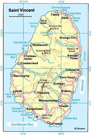
The Rabacca Dry River is a river of Saint Vincent and the Grenadines. It is a seasonal river and will only flow like a normal when there is heavy rainfall. It is located on the outskirts of Georgetown. It was formed as a result of the eruption of the La Soufriere volcano, there is its source.
| Rabacca Dry | |
|---|---|
 The Rabacca or Dry River, Soufriere Mountain in the distance. Painted ca. 1836 | |
| Nickname(s) | Dry River |
| Location | |
| Country | Saint Vincent and the Grenadines |
| Region | Charlotte |
| Physical characteristics | |
| Source | La Soufrière |
| • elevation | 4,048 m (13,281 ft) |
| Mouth | Rabacca |
• location | Atlantic Ocean |
• coordinates | [1] |
• elevation | 0 m (0 ft) |
| Length | 8 km (5.0 mi) |
See also
References
- Nile River at GEOnet Names Server
- GEOnet Names Server
- Tourist Map
- Environmental Investigation and Cataloguing, St. Vincent Cross Country Road Project Final Report
На других языках
[de] Rabacca Dry River
Der Rabacca Dry River ist ein temporärer Fluss an der Ostküste der Karibikinsel St. Vincent.- [en] Rabacca Dry River
Текст в блоке "Читать" взят с сайта "Википедия" и доступен по лицензии Creative Commons Attribution-ShareAlike; в отдельных случаях могут действовать дополнительные условия.
Другой контент может иметь иную лицензию. Перед использованием материалов сайта WikiSort.org внимательно изучите правила лицензирования конкретных элементов наполнения сайта.
Другой контент может иметь иную лицензию. Перед использованием материалов сайта WikiSort.org внимательно изучите правила лицензирования конкретных элементов наполнения сайта.
2019-2025
WikiSort.org - проект по пересортировке и дополнению контента Википедии
WikiSort.org - проект по пересортировке и дополнению контента Википедии