geo.wikisort.org - River
The Lauwers (Dutch pronunciation: [ˈlʌuʋərs]) is a river in the Netherlands. It forms part of the border between the provinces of Friesland and Groningen. From the 730s to Widukind's defeat in 785, it was part of the border of the Frankish Empire.
This article does not cite any sources. (December 2009) |
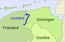
The former Lauwerszee and the present-day Lauwersmeer are both named after the river, which as a small stream has its source southeast of the village of Surhuisterveen. Near Gerkesklooster/Stroobos, it crosses the Prinsesmargrietkanaal/van Starkenborghkanaal.
The Lauwers achieves the width of a true river at the place that it gains its tributary, the Oude Vaart, near the Schalkendam. Further along its course, the Lauwers splits into two branches, the Frisian Oude Lauwers and the Zijldiep, in Groningen province.
The Lauwers meets the sea at the Wadden Sea, emptying into a channel between the islands of Schiermonnikoog and Rottumerplaat/Rottumeroog, which can be viewed as the continuation of the river.
 Lauwers River

На других языках
[de] Lauwers
Die Lauwers (gronings Laauwers; veraltet Laubeke oder deutsch Laubach) ist ein rund 40 Kilometer langes Flüsschen im Norden der Niederlande, das im Osten der Provinz Friesland in der Gemeinde Achtkarspelen entspringt, im weiteren Verlauf nach Norden fließt und die Grenze zur Provinz Groningen bildet bis zum Dorf Munnekezijl (Gemeinde Noardeast-Fryslân). Hier wird das Gewässer in einen Kanal (Munnekezijlsterried) gefasst, der das Wasser der Lauwers am Dorf Lauwerzijl (Gemeinde Westerkwartier) vorbei und neben das Groninger Reitdiep führt, mit dem es nahe Zoutkamp über das Zoutkamperril in das Lauwersmeer mündet, die vormalige Lauwerszee im Nationalpark Lauwersmeer.- [en] Lauwers
[it] Lauwers
Il Lauwers (in Gronings: Laauwers) è un fiume del nord dei Paesi Bassi, che scorre per circa 40 km lungo il confine tra le province della Frisia e di Groninga[1]. Sfocia nel Lauwersmeer (ex-Lauwerszee).[1][2][ru] Лауэрс (река)
Лауэрс (з.-фриз. и нидерл. De Lauwers) — река на севере Нидерландов. Длина — 40 км. Впадает в канал Зауткамперрил.Другой контент может иметь иную лицензию. Перед использованием материалов сайта WikiSort.org внимательно изучите правила лицензирования конкретных элементов наполнения сайта.
WikiSort.org - проект по пересортировке и дополнению контента Википедии