geo.wikisort.org - River
The Fino is a river in eastern central Italy. Its source is near Monte Camicia in the province of Teramo in the Abruzzo region of Italy.[1] The river flows northeast and then curves east before flowing past Bisenti.[2] It continues flowing eastward and crosses into the province of Pescara near Elice. The river flows southeast until it joins the Tavo river and the two rivers become the Saline river.
| Fino | |
|---|---|
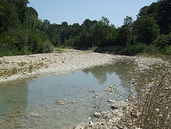
 The Fino near Bisenti | |
| Location | |
| Country | Italy |
| Physical characteristics | |
| Source | |
| • location | Monte Camicia |
| Mouth | Saline |
• coordinates | 42.4843°N 14.0953°E |
| Basin features | |
| Progression | Saline→ Adriatic Sea |
References
- Hammond World Atlas (6 ed.). Hammond World Atlas Corporation. 2010. p. 71. ISBN 9780843715606.
- The Times Comprehensive Atlas of the World (13 ed.). London: Times Books. 2011. p. 77. ISBN 9780007419135.
На других языках
[de] Fino (Fluss)
Der Fino ist ein Fluss in der italienischen Region Abruzzen mit ungefähr 49 km Länge.[1]- [en] Fino (river)
[it] Fino (fiume)
Il fiume Fino nasce sul Gran Sasso, dal versante nordorientale del monte Tremoggia (m. 2.331)[1], a 1.200 metri s.l.m., e scorre tortuosamente in direzione W-E, SW-NE, perpendicolarmente alla costa e trasversalmente rispetto alla dorsale montuosa, profondamente incassato in valli e forre.Текст в блоке "Читать" взят с сайта "Википедия" и доступен по лицензии Creative Commons Attribution-ShareAlike; в отдельных случаях могут действовать дополнительные условия.
Другой контент может иметь иную лицензию. Перед использованием материалов сайта WikiSort.org внимательно изучите правила лицензирования конкретных элементов наполнения сайта.
Другой контент может иметь иную лицензию. Перед использованием материалов сайта WikiSort.org внимательно изучите правила лицензирования конкретных элементов наполнения сайта.
2019-2025
WikiSort.org - проект по пересортировке и дополнению контента Википедии
WikiSort.org - проект по пересортировке и дополнению контента Википедии