geo.wikisort.org - River
The Castries River is a river in Castries Quarter on the island country of Saint Lucia.[1][2][3]
| Castries River | |
|---|---|
 | |
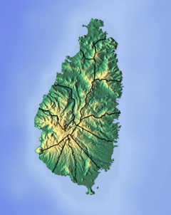 Location of mouth | |
| Location | |
| Country | Saint Lucia |
| Region | Castries Quarter |
| Physical characteristics | |
| Mouth | Caribbean Sea |
• location | Castries, Saint Lucia |
• coordinates | 14°01′N 60°59′W |
See also
References
- "Castries River". National Geospatial Intelligence Agency. Retrieved August 3, 2021.
- "Integrating the Management of Watersheds and Coastal Areas in St. Lucia". Water Resources Management Unit, Ministry of Agriculture, Forestry and Fisheries Government of St. Lucia. 2001. Retrieved August 3, 2021.
- Breen, Henry H. (1844). St. Lucia: Historical, Statistical, and Descriptive. London: Longman, Brown, Green, and Longmans. pp. 10, 23, 24.
- Higgins, Chris (2001). St. Lucia. Montreal: Ulysses Travel Guides. ISBN 2-89464-396-9.
На других языках
[de] Castries River
Der Castries River ist ein Fluss an der Westküste der Karibikinsel St. Lucia. Er trägt den Namen der gleichnamigen Bucht und der Hauptstadt der Insel.- [en] Castries River
Текст в блоке "Читать" взят с сайта "Википедия" и доступен по лицензии Creative Commons Attribution-ShareAlike; в отдельных случаях могут действовать дополнительные условия.
Другой контент может иметь иную лицензию. Перед использованием материалов сайта WikiSort.org внимательно изучите правила лицензирования конкретных элементов наполнения сайта.
Другой контент может иметь иную лицензию. Перед использованием материалов сайта WikiSort.org внимательно изучите правила лицензирования конкретных элементов наполнения сайта.
2019-2025
WikiSort.org - проект по пересортировке и дополнению контента Википедии
WikiSort.org - проект по пересортировке и дополнению контента Википедии