geo.wikisort.org - Reservoir
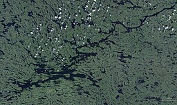
Lake Minto (Inuktitut: Qasigialik, "where there are spotted seals") is a lake on western Ungava Peninsula, Nunavik, Quebec, Canada. It has a total surface area of 761 square kilometres (294 sq mi) and a net area of 703 square kilometres (271 sq mi).[3]
| Lake Minto | |
|---|---|
 | |
| Location | Baie-d'Hudson, Kativik, Quebec |
| Coordinates | 57°13′07″N 75°00′45″W |
| Type | Oligotrophic |
| Primary inflows | Charpentier River and other rivers |
| Primary outflows | Leaf River |
| Basin countries | Canada |
| Max. length | 81 km (50 mi) [1] |
| Max. width | 22 km (14 mi) [1] |
| Surface area | 761 km2 (294 sq mi) [2] |
| Surface elevation | 168 m (551 ft) [2] |
It was named by Canadian explorer and geologist Albert Peter Low in 1898 after Gilbert Elliot-Murray-Kynynmound, 4th Earl of Minto, who was Governor General of Canada at that time.[1]
It is only some 60 kilometres (37 mi) east of Hudson Bay in a valley between several rows of hills, but Lake Minto's outlet, the Leaf River, flows north-east for about 265 kilometres (165 mi) to Ungava Bay. As such, it is used by canoeists especially when crossing Ungava from west to east.[1][4][5]
It is considered one of the most beautiful lakes in northern Quebec.[1]
References
- "Lac Minto" (in French). Commission de toponymie du Québec. Retrieved 2010-12-13.
- Statistics Canada > summary tables > Principal lakes, elevation and area, by provinces and territories Archived 2011-07-06 at the Wayback Machine
- Natural Resources Canada, Atlas of Canada - Lakes Archived 2007-04-10 at the Wayback Machine
- "Northern Ungava Canoe Expedition". Archived from the original on 2008-07-19. Retrieved 2011-05-21. Northern Ungava Canoe Expedition
- http://www.nrsweb.com/services/newsletter/2007/rtnStory_0207b.asp Crossing the Ungava
На других языках
[de] Lac Minto
Lac Minto (englisch Lake Minto; Inuktitut: Qasigialik („wo es Largha-Robben gibt“)) ist ein See im Westen der Ungava-Halbinsel, in der Region Nunavik in der kanadischen Provinz Québec.- [en] Lake Minto
[es] Lago Minto
El lago Minto (en francés, Lac Minto; en inglés, Lake Minto; en inuktitut, Qasigialik, donde hay focas manchadas) es un lago de Canadá localizado en la parte occidental de la península de Ungava, en la región de Nunavik del norte de la provincia de Quebec.[fr] Lac Minto
Le lac Minto est un plan d'eau du territoire non organisé de Baie-d'Hudson, au Nunavik, dans la région administrative du Nord-du-Québec, au Québec, au Canada.[ru] Минто (озеро)
Минто[2] (фр. Lac Minto) — озеро в провинции Квебек в Канаде. Расположено в слабо заселённой северо-западной части провинции на западе полуострова Унгава (полуостров Лабрадор). Одно из больших озёр Канады — площадь водной поверхности 703 км², общая площадь — 761 км², седьмое по величине озеро в провинции Квебек. Высота над уровнем моря 168 метра[1], колебания уровня озера до 1,09 метра. Ледостав с ноября по июль.[3]. Озеро сложной формы, с рукавами и заливами, имеет множество островов, вытянуто в направлении с юго-запада на северо-восток на 81 километр.Другой контент может иметь иную лицензию. Перед использованием материалов сайта WikiSort.org внимательно изучите правила лицензирования конкретных элементов наполнения сайта.
WikiSort.org - проект по пересортировке и дополнению контента Википедии
