geo.wikisort.org - Île
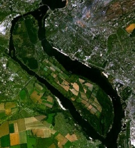
Khortytsia (ukrainien : Хортиця, russe : Хортица) est une île fluviale ukrainienne. Plus longue (12 kilomètres) et plus étendue (27 km²) des îles du Dniepr, elle se situe sur le territoire de Zaporijia, en aval du principal barrage hydroélectrique de la compagnie Dnipro-HES.
Cet article est une ébauche concernant l’Ukraine et le monde insulaire.
Vous pouvez partager vos connaissances en l’améliorant (comment ?) selon les recommandations des projets correspondants.
| Pays | |
|---|---|
| Oblast |
Oblast de Zaporijjia |
| Coordonnées |
47° 49′ 12″ N, 35° 06′ 00″ E |
| Superficie |
23,6 km2 |
| Nom local |
(uk) Хортиця |
|---|---|
| Patrimonialité |
Registre national des monuments d'Ukraine sous le numéro : 23-101-9001 registre culturel naturel sous numéro : 23-101-5007 |
 |

L'île de Khortytsia est une terre sacrée pour les Cosaques ukrainiens. C'est dans cette île que fut édifié le camp militaire historique des Cosaques zaporogues, la sitch, rasé par Catherine II, impératrice de Russie, pour assurer son pouvoir sur l'Ukraine, et reconstruit à l'identique peu après l'indépendance du pays en 1991. Elle est inscrite au Registre national des monuments d'Ukraine sous le numéro : 23-101-9001 et au registre culturel naturel sous numéro : 23-101-5007 et fait partie des Sept merveilles d'Ukraine.
Sites
- Musée des cosaques de Zaporijjia,
- l'église de l'intercession de Khortytsia.
Images
 Entrée du Musée des cosaques de Zaporijjia.
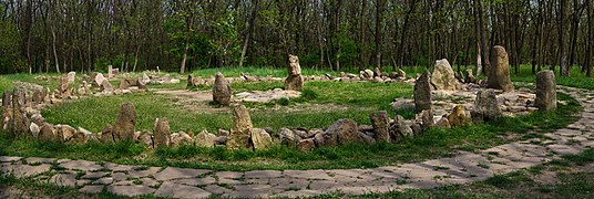 Sanctuaire Braharnya.
 Avec un cercle de pierres au premier plan.


Documentation
- (de) Jana Bürgers, « Mythos und Museum. Kosakenmythos und Nationsbildung in der postsowjetischen Ukraine am Beispiel des Kosakengeschichtsmuseums auf der Insel Chortycja. », dans Bianka Pietrow-Ennker (dir.), Kultur in der Geschichte Russlands, Göttingen : Vandenhoeck & Ruprecht, 2006. (ISBN 3-525-36293-5)
- (de) Christian Ganzer, Sowjetisches Erbe und ukrainische Nation. Das Museum der Geschichte des Zaporoger Kosakentums auf der Insel Chortycja, Stuttgart : Ibidem-Verlag, 2005 (Soviet and Post-Soviet Politics and Society, vol. 19). (ISBN 3-89821-504-0)
Notes et références
 Portail de l’Ukraine
  Portail du monde insulaire
  Portail des lacs et cours d'eau
На других языках
[de] Chortyzja
Chortyzja (ukrainisch Хортиця .mw-parser-output .Latn{font-family:"Akzidenz Grotesk","Arial","Avant Garde Gothic","Calibri","Futura","Geneva","Gill Sans","Helvetica","Lucida Grande","Lucida Sans Unicode","Lucida Grande","Stone Sans","Tahoma","Trebuchet","Univers","Verdana"}Chortyzja, russisch Хортица Chortiza) ist die größte Insel im Dnepr. Sie liegt in der östlichen Ukraine im Rajon Chortyzja der Stadt Saporischschja unterhalb der großen Staumauer des Wasserkraftwerkes DniproHES. Die Insel wird westlich vom Staryj Dnipro (Alter Dnepr) und östlich vom Hauptstrom umflossen. Sie hat eine Fläche von etwa 24 km² (rund 12 km lang und maximal rund 2,5 km breit) und wird in der Ukraine gelegentlich als „größte Flussinsel Europas“ bezeichnet,[1] fälschlicherweise, da die Inseln Wilhelmsburg in der Elbe und die Große Schüttinsel in der Donau deutlich größer sind.[en] Khortytsia
Khortytsia (Ukrainian: Хо́ртиця, romanized: Xórtycja / Khórtytsya, pronounced [ˈxɔrtɪtsʲɐ]) is the largest island in the Dnieper river, and is 12.5 km (7.77 mi) long and up to 2.5 km (1.55 mi) wide.[1] The island forms part of the Khortytsia National Park.[1] This historic site is located within the city limits of Zaporizhzhia,[2] Ukraine.- [fr] Khortytsia
[it] Chortycja
Chortycja (in ucraino: Хо́ртиця?; in russo: Хо́ртица?, traslitterato: Chortica; in polacco Chortyca) è la più grande isola del fiume Dnepr situata a Zaporižžja, in Ucraina.[1][ru] Хортица
Хо́ртица (укр. Хортиця) — крупнейший остров на Днепре, расположен в черте города Запорожье ниже днепровских порогов (теперь у ДнепроГЭС). Национальный историко-культурный заповедник[1][2]. Остров вытянут с северо-запада на юго-восток, длина — 12,5 км, ширина — в среднем 2,5 км.Другой контент может иметь иную лицензию. Перед использованием материалов сайта WikiSort.org внимательно изучите правила лицензирования конкретных элементов наполнения сайта.
WikiSort.org - проект по пересортировке и дополнению контента Википедии