geo.wikisort.org - Island
Storfosna is a populated island in the municipality of Ørland in Trøndelag county, Norway. The 11-square-kilometre (4.2 sq mi) island is located between the islands of Kråkvåg and Garten north of the mouth of the Trondheimsfjorden. The traditional district of Fosen is named after this island. There is a large deer population on the island.[1]
 View of the island (looking north) | |
 | |
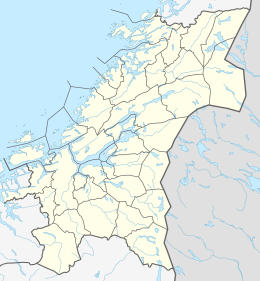 Storfosna Location of the island  Storfosna Storfosna (Norway) | |
| Geography | |
|---|---|
| Location | Trøndelag, Norway |
| Coordinates | 63.6678°N 09.4070°E |
| Area | 11 km2 (4.2 sq mi) |
| Length | 6 km (3.7 mi) |
| Width | 3 km (1.9 mi) |
| Highest elevation | 158 m (518 ft) |
| Highest point | Fosenfjellet |
| Administration | |
Norway | |
| County | Trøndelag |
| Municipality | Ørland |
The island is connected to the island of Kråkvåg by a causeway and bridge, and is connected to Garten (and the mainland) by a car ferry. The Storfosna Church is located on the island. The local and county governments are planning to build an undersea tunnel connecting Storfosna to the island of Garten (which is connected to the mainland by road).[2]
See also
References
- Haugen, Morten, ed. (2017-08-20). "Storfosna". Store norske leksikon (in Norwegian). Kunnskapsforlaget. Retrieved 2018-02-24.
- "Tunnel mellom Garten og Storfosna". NRK (in Norwegian). Retrieved 2019-03-02.
This Trøndelag location article is a stub. You can help Wikipedia by expanding it. |
Другой контент может иметь иную лицензию. Перед использованием материалов сайта WikiSort.org внимательно изучите правила лицензирования конкретных элементов наполнения сайта.
WikiSort.org - проект по пересортировке и дополнению контента Википедии