geo.wikisort.org - Coast
Cabo Touriñán is a small peninsula that is the most westerly point of Peninsular Spain.[1] It is located in the municipality of Muxía, which is itself located within the province of A Coruña and the autonomous community of Galicia. The Cape, along with the rest of Muxía, is best known as a destination for pilgrims who extend the Camino de Santiago by walking to the Atlantic coast after reaching the holy city of Santiago de Compostela.[2]

Description
The cape is a small peninsula that juts about 1 km into the sea, the narrowest section being an isthmus 150 metres wide between the coasts of Balal and Cuño. Its maximum altitude is 93 metres above sea level. The rock is made of is granite, the erosion of which has caused the formation of deposits of pebbles, known as coídos, and stony bars, which formed an islet such as the so-called A Ínsua on the west side of the cape. The western point of the cape, Os Buxeirados, has a series of rocks that go into the sea around 300 to 400 m, known as A Laxe de Buxeirados or Bajos de Buxeirados. The rocks have proved dangerous for navigation, causing some serious shipwrecks.
Its rugged landscape causes the cape to have vegetation to be basically just thorny reed or gorse like Ulex eruopaeus. In the north of the cape, there is a lighthouse and complementary buildings that were established 15 December 1898.[3]
Name
The name comes from the nearby parish of Touriñán, in which the cape is located, and that must go back to the Latin name, which is supposed to be "Taurinius" or "Taurinianus" through the genitive "Tauriniani".
Gallery
 Illa do Castelo.
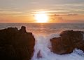


See also
- Cape Finisterre
- Extreme points of Spain
- Touriñán Lighthouse
References
- Molina, César Antonio (Nov 2003). Viaje a la costa de la muerte (in Spanish). Huerga Y Fierro Editores. p. 222. ISBN 978-8483743904. Retrieved 26 April 2015.
- Alya (2022-03-28). "The Camino Finisterre - a 2022 guide & walking stages". STINGY NOMADS. Retrieved 2022-07-27.
- José., Baña Heim (1980). Viaje a la Costa de la Muerte con la historia y anecdotario de sus naufragios. Venus (4a. ed. rev. y aum ed.). [S.l.]: J. Baña. ISBN 8440400285. OCLC 434519936.
{{cite book}}: CS1 maint: ignored ISBN errors (link)
This Spain location article is a stub. You can help Wikipedia by expanding it. |
На других языках
- [en] Cabo Touriñán
[es] Cabo Touriñán
El cabo Touriñán o cabo de Touriñán es el punto más occidental de la provincia de La Coruña, de toda Galicia y de la España peninsular, así como el segundo de Europa.[1] Está situado en el municipio de Mugía.[ru] Ториньяна
Ториньяна[1] (исп. Cabo Touriñán) — мыс и крайняя западная точка материковой Испании. Мыс расположен около города Мухиа в провинции Ла-Корунья в составе автономного сообщества Галисия.Другой контент может иметь иную лицензию. Перед использованием материалов сайта WikiSort.org внимательно изучите правила лицензирования конкретных элементов наполнения сайта.
WikiSort.org - проект по пересортировке и дополнению контента Википедии